Please help the next visitor by writing a few lines about the beach, are there toilets? Is it shallow? Is there a jetty or maybe a kiosk?
Beaches close to Kells
Rossbeigh Beach is a sandy beach that faces west into Dingle Bay and the Atlantic Ocean. The beach is protected by a shingle ridge and surrounded by extensive sand dunes, which are home to a variety of rare plant and animal species. The area also features salt marshes and mudflats that support many bird species. Rossbeigh Spit falls within the Castlemaine Harbour Special Area of Conservation and is protected under EU laws. Additionally, parts of Castlemaine Harbour and Dingle Bay are Special Protection Areas and designated as shellfish areas. Visitors can enjoy activities such as pony trekking, golf, and angling, which are regulated by the Kerry County Council Beach Bye-Laws of 2013.
Cúas Crom Beach, located in Caherciveen, is a popular spot for swimming with little to no currents in the sheltered cove. Despite its stony beach, the water is warm and clear. The beach hosts an annual Christmas Day Swim and is adjacent to excellent walking routes towards Knocknatobar Mountain, Dolus Head, Ballycarbery Castle, and the historical stone forts of Cahergal and Leacanabuaile.
Inch Strand is a west-facing sandy beach that overlooks Dingle Bay and the Atlantic Ocean. The beach's sand dune system houses a diverse range of plant species, with additional salt marsh and mudflat areas providing a habitat for various bird species. Inch Spit is situated within the greater Castlemaine Harbour Special Area of Conservation, and parts of Castlemaine Harbour and Dingle Bay are designated Special Protection Areas for birds and shellfish. Activities on the beach are regulated by the Kerry County Council Beach Bye-Laws, 2013. The identified bathing waters on Inch Spit comprise only 1.4km of the beach's full length of approximately 5km.
White Strand is a small sandy cove facing west, approximately 450m long. It is protected from the Atlantic's waves by Beginish Island. The surrounding land is mostly used for farming and consists of grassland. The area, including Valentia Harbour and the beach, is designated as Special Area of Conservation, while the land south of the beach is designated as Special Protection Area. Visitors enjoy windsurfing, canoeing, and fishing. Kerry County Council has restrictions in place for certain activities under the 2013 Beach Bye-Laws.
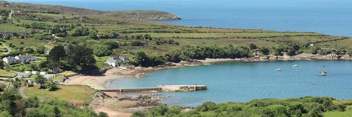
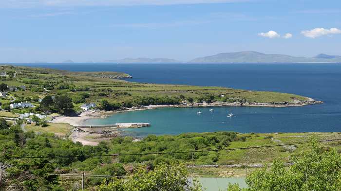
A tranquil pebble beach with a touch of sand, safe shallow waters ideal for kids to swim and paddle. The stunning beauty of the Dingle Peninsula and Inch Beach are visible across the water.
Fionntrá beach is protected from the elements, facing east/southeast onto Cuan Fionntrá, an inlet of Dingle Bay. The sandy beach is surrounded by sand dunes covered with marram grass and wetland and grassland beyond. Kerry County Council regulates activities according to the Beach Bye-Laws of 2013. Fionntrá is situated in the South Western River Basin District and is about 7km west of an Daingean.
Trá na hUíne, situated on the beautiful Ballinskelligs Bay, is a sandy beach backed by an extensive sand-dune system. It is approximately 2km from the village of Waterville in south Kerry and features a south-westerly facing aspect. The beach is primarily used for swimming, walking, windsurfing, and fishing, and there is public car parking available at the southern end of the beach with a convenient concrete ramp leading on to the sand.
Reenroe beach, located between Waterville and Ballinskelligs, offers a beautiful coastal experience perfect for watersports. Its sandy bottom is ideal for those new to surfing.
Waterville beach borders Ballinskelligs Bay and is situated near the town. The beachfront has been altered to provide access to the rocky shoreline, a coastal path, and other amenities.
Baile an Sceilg is a protected beach situated beside the village of the same name. Horse Island shields it from the rough waters of the Atlantic, but it is exposed to winds from the south. The surrounding area is a mix of agricultural and tourist developments. The Ballinskelligs Bay and River Inny estuary are recognized as Special Areas of Conservation due to their unique ecosystems. The Kerry County Council Beach Bye-Laws, 2013 govern several activities on the beach. While the full extent of the beach measures 1km, only 400m is designated as a safe bathing area.